• This morning, we hiked from the Refuge de Balme (1706 m.) up to the Col du Bonhomme (2329 m.). There were many other hikers on the trail, and everyone pauses at the pass, where the views are dramatic in all directions.
• The trail from the Col du Bonhomme traverses a steep and rocky mountain slope to reach a point (2479 m.) above the Col de la Croix du Bonhomme and then descends a short distance to the Refuge du Col de la Croix de Bonhomme. We had lunch at the refuge.
• The Tour du Mont Blanc and the GR5 separate at the refuge. So we bade farewell to the many TMBers on the trail and followed our GR5 southwest from the refuge.
• During the next hour, we hiked over the Crête des Gittes, reaching a high point close to 2538 m. We remembered this section of the trail from our hike in 1989. It's dramatic – "aérien" in French mountaineering terminology (which could be translated in this context as "exposed").
• The final two hours of the hike – a long descent from 2538 m. to 1818 m. – were less enjoyable, but brought us to the very pleasant Gîte d'Alpage de Plan Mya (1860 m.).
* * *
6:57 am at the Refuge de la Balme: It's worth getting out of bed for a sight like this!

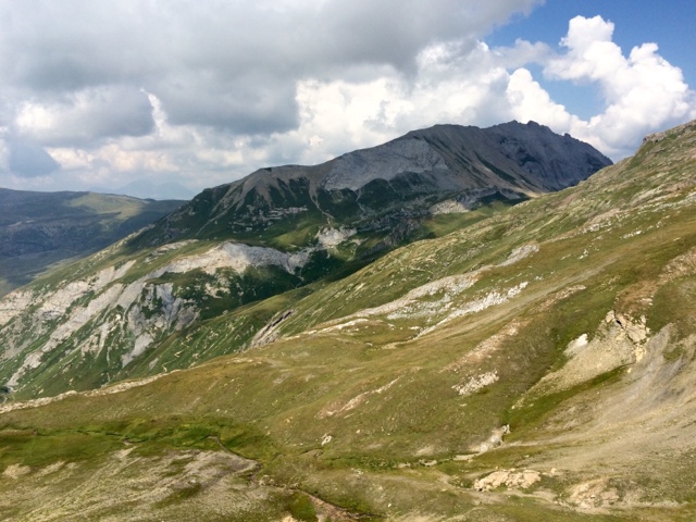
The hike from the Refuge de la Balme to the Col du Bonhomme:

What, me worry?

Waterworks and a high voltage power line on our trail:

We passed the large "tumulus" in the Plan des Dames, where, according to a legend, an English woman and her servant died during a terrible storm. To ward off her fate and bad luck generally, one adds a stone to the pile. Recalling Pascal's Wager, we took no chances and tossed rocks, in accordance with the tradition.


Approaching the Col du Bonhomme:


This was the first snow that we've seen near the trail:


Col du Bonhomme, the boundary between the Departments of Haute Savoie (74) and Savoie (73).


A herd of sheep crossed the pass while we were there.

The trail from the Col du Bonhomme to the Col de la Croix du Bonhomme traverses a rocky slope, with dramatic views of the surrounding mountains.


The Refuge du Col de la Croix du Bonhomme has a big place in our family history. Located at the point where the TMB and the GR5 diverge, it attracts many hikers. It was a drafty old stone building during our visits in the 1980s (Carroll's TMB in 1984; Carroll & Mary's TMB in 1986; Carroll & Mary's GR5 in 1989). A new refuge (incorporating parts of the old) was constructed in 1990. Carroll camped nearby when hiking the Tour du Beaufortain in 1994, and he and Chloé stayed there when hiking part of the TMB in 2009.

The old stone building was incorporated in the new refuge. The refuge now has 110 places. People who were there last night told us that the refuge was full.


Photos taken during our hike on the Crête des Gittes, showing the trail itself and the stunning views of the surrounding mountains:


Looking down at this point, we were intrigued to see birds soaring in circles below us.

Descending from the Crête des Gittes, we could see our destination, Plan de Mya, in the distance – more than two hours away...


The Gîte d'Alpage de Plan-Mya: We really enjoyed our stay at this refuge. It's a small, converted farmhouse. The people who live here (and continue to work a herd of dairy cattle) are very hospitable; the place buzzes with activity, as customers and friends come for a drink or a meal. Our dinner here was excellent, and we enjoyed getting acquainted with friendly and interesting people around the table (not all of whom are included in these photos; we missed a few of those folks, unfortunately).


No comments:
Post a Comment