I won't swamp this blog with numerous, daily posts. I'll just add periodic, brief reports, with a few photos, to this blog post, with the most recent at the top.
30 July 2016: Refuge Alfred Wills
This was a special weekend: Mary, who is working this summer, had three days off, so (by traveling overnight) she was able to join me in Verchaix. She arrived on Friday, in time to attend the annual Assemblée Générale of our copropriété. Such meetings can be rather tedious, but they are a good opportunity to see some of our neighbors.
The highlight of the weekend was our hike to the Refuge Alfred Wills on Saturday. We like the trail from Lignon up to the Collet d'Anterne and then down to the broad basin in which the refuge is located. Dark clouds rolled in and the wind rose as we approached the refuge, but only light rain fell during hike back down.
Mary pauses as we approach the Collet d'Anterne:

View of Salvagny in the valley:


Delicious tarte myrtilles at the refuge:


We broke out the rain gear for the walk back down the trail:


28 July 2016: Les Gorges des Tines
Another modest hike today: Departing from Le Perret (a couple of kilometers from Samoëns, on the road toward Sixt-Fer-à-Cheval), I hiked through the Gorges des Tines. Short, but dramatic!
This is a section of the GR5. Observing the GR blaze on the tree, I recalled my first walk on this trail and my passage through the Gorges des Tines -- in July 1984.


The interesting section of the Gorges des Tines begins here. Ladders, cables and handrails are bolted to the rocks to facilitate the hiker's passage.


Descending back to the river, one sees (and hears!) a plant that sorts gravel that has been dredged from the river.

Nearby, there is a rockface that is used for climbing instruction. Some of the children here today were quite young -- and doing quite well! I recall that William did some climbing here, back in the day...

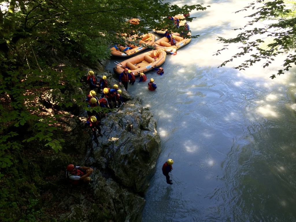
Rafting on the Giffre River is popular. The passage through the narrow gorge is dramatic, and there is a spot right after the gorge where rafts often stop so that the rafters can enjoy jumping into the river from a rock. I recall doing that with William & Chloé, back in the day...

27 July 2016: Refuge du Folly
I was hoping to be pushing myself on long, demanding hikes by now, but the ankle that I twisted during the descent from Lac des Chambres a week ago is still bothering me. So I opted today for a more modest hike: up to the Refuge du Folly and back (2 hours each way). Charlotte, the gardienne, and Tendi, her assistant, welcomed me warmly, and I enjoyed a traditional lunch there (farcement, salade et tarte au citron).
To vary the experience a bit, I departed from the lower parking area, Le Pied du Crêt (889 m.), which leads to this bucolic scene (instead of the exposed Dalle du Tuet that one crosses after starting from Le Crêt):

The trail climbs steadily in the forest for almost two hours:

Views from the terrace of the Refuge du Folly (1560 m.):


24 July 2016: Col de la Golèse
The sun returned today, albeit sharing the sky with threatening clouds that finally delivered rain in the evening. I hiked from the parking area above Les Allemands (1096 m.) on a trail (actually a dirt and rock road) that climbed steadily to the Refuge de Bostan (1763 m.). I then followed the trail that departs from the refuge and traverses a slope to arrive at the Col de la Golèse and the Refuge de la Golèse (1671 m.). The GR5 crosses the Col de la Golèse; Mary and I stopped for coffee at the refuge during our hike last year. Having picnicked on the trail, I enjoyed a pause-café at the refuge today. I then followed the GR5 down a dirt road back to the parking area.
The trail began in the forest:

Looking back after the trail emerged from the forest:

Looking ahead as the trail climbs toward the Refuge de Bostan (and the Col de Bostan beyond the refuge):

A Dorgan tradition: cows on the trail.


Arrival near the Refuge de Bostan, with clouds forming...


Descending toward the Col de la Golèse:

Col & Refuge de la Golèse:

View of Samoëns in the valley on the road descending from the Col de la Golèse:

23 July 2016: Tour de France
The last stage of the Tour de France, before the largely ceremonial finish on the Champs Elysées tomorrow, passed through Samoëns today. The final challenge of the day was the climb from Samoëns (695 m.) to the Col de Joux Plane (1691 m.), classified "hors catégorie" (which means it's a tough climb!). The weather was also a big challenge: heavy rain!
I walked from Verchaix to a point on the road leading to the pass where I could watch the cyclists, Le Clos Parchet, near the Ecomusée that I visited two weeks ago. I found shelter from the rain in the farm building's "courtine" while waiting for the cyclists to arrive.
Il pleuvait des cordes!

The rain did not discourage hard-core fans of the Tour de France, who waited patiently in the rain. Some of them, of course, had cars and vans for shelter.


Here's a video showing the first two cyclists who had broken away from the peleton, followed by the usual enormous entourage of cars (Tour officials, team managers, etc.):
https://www.youtube.com/watch?v=9KMAB6MLvEg
I was struck by the grim determination of the cyclists -- not much expression on their faces, just stoic perseverance -- as they pedaled up this steep climb in such difficult conditions.

Here's Froome, the leader (maillot jaune), led by two of his teammates. Barring some accident, Froome will win the Tour de France tomorrow.

The voiture balai (the "broom car") drives behind the last of the riders and picks up any who abandon the race.

21 July 2016: Refuge Alfred Wills
With rain predicted in the afternoon and my ankle still sore from a twist that I suffered descending from Lac des Chambres two days ago, I chose a relatively modest hike today: from Lignon (1180 m.) to the Refuge Alfred Wills (1810 m.) -- 3½ hours up, and 3½ back. It's a beautiful hike (it is, in fact, a short section of the GR5), with splendid views of the Giffre Valley, la Cathédrale (2531 m.), le Grenier de Commune (2775 m.) and Mont Buet (3095 m.) as one hikes around the Collet d'Anterne. Then the towering barricade of the Rochers de Fiz encloses the broad basin of the Montagne d'Anterne, where the refuge is located. The GR5 continues beyond the refuge, of course: It climbs the big hill behind the refuge, descends to Lac d'Anterne, climbs to the Col d'Anterne, and so on ... to Nice.
A section of this trail is very slippery when wet. It was dry when I hiked up the trail in the morning, but the light rain that started when I left the refuge in the afternoon was enough to make that section slippery; I fell twice.
A view from the trail over Sixt-Fer-à-Cheval and Salvagny:

The view during the approach to the Collet d'Anterne: la Cathédrale and le Grenier de Commune on the left; Mont Buet on the right:

Mont Buet:

Approaching the basin called la Montagne d'Anterne, with the Rochers des Fiz standing guard on the right:


I was not alone on the trail...

Alfred Wills QC was an English lawyer and High Court judge in the second half of the 19th century (he presided over the trial of Oscar Wilde). An avid mountaineer, he had a chalet in the nearby Alpage des Fonds, which was his base for numerous hikes and climbs in the area.
Here's the refuge named after him (http://www.refuge-wills.com). The GR5 trail can be seen climbing on a diagonal line behind and to the right of the refuge.

19 July 2016: Lac des Chambres
The heat wave gripped France today. Here in Verchaix, it was over 30° in the shade. I decided to hike from Le Crêt (997 m.) to Lac des Chambres (2025 m.), which was a bit ambitious in these conditions. The spectacular beauty of the lake made the effort worthwhile! But I twisted my ankle slightly while hiking down the steep trail from the lake -- and I'm really tired now...


Views during the walk back down from the lake:


18 July 2016: Pas du Boret
Under blazing sunshine, I hiked up the Pas du Boret (an "aérien" -- exposed -- trail) to the Buvette du Boret (1380 m.). I bought a beer and asked the woman who runs the place if I could eat my picnic lunch there with my beer. "Mais bien sûr!...", she said with a smile. I really appreciate such hospitality!
I enjoy the challenge of hiking up the Pas du Boret, but hiking back down that trail does not appeal to me. (I've done it once, with Mary and William.) So, as usual, I hiked back on the trail that goes to "Le Bout du Monde" at the head of the Fer-à-Cheval valley.
The climb up the Pas du Boret begins here, next to the Chalet de Prazon in the valley (ca. 1020 m.):
The Pas du Boret trail crosses the green patch in the left-center of this photo:
With some zoom, hikers can be seen on the Pas du Boret trail:

Looking down on the Pas du Boret trail:

Views of the valley from the Pas du Boret trail:


The Chalet du Boret (buvette):

Yet another photo of the view from "Le Bout du Monde":

The Fer-à-Cheval, with waterfalls:

15 July 2016: Chalets de Salvadon
France is in mourning today, following the terrible terrorist attack on the Promendade des Anglais in Nice last night. Watching the news this morning, I reflected upon my walk with Mary along that Promenade and the beach at the end of our hike on the GR5 last year...
As if to defy that terrorist, sunny weather returned to France today, after several days of rain. I hiked up a steep trail from a hamlet called le Crot (818 m.) to the Chalets de Salvadon (1720 m.) and back, a good workout.

The lower Vallée de Sales, with the Cascade du Rouget and the Cascades de la Pleureuse and de la Sauffaz, is visible across the valley:

That's fresh snow from the abudant precipitation of recent days:


A great cirque embracing the Chalets de Salendon:

Views on the way back down the trail:


A mobile milking station on the left, with contented cattle chewing their cud on the right:


11 July 2016: Lac de Gers
I hiked today from the Pont de Lededian (1180 m.) to the Lac de Gers (1544 m.) and back. It was mostly just a walk along a dirt road in the forest, but the lake in its large cirque is quite beautiful.


9 July 2016: Chalets du Trot
The hike from Vallon d'en Haut (717 m., outside Samoëns) up to the Chalets du Trot (1400 m.) is another good one for a hot, sunny day. The trail zigzags up a fairly steep slope within a forest that offers welcome shade. One emerges from the forest at the Chalets du Trot, with good views over the valley toward (inevitably) Mont Blanc. One of those chalets is a buvette, run by a very friendly couple. I bought a beer there to accompany my picnic lunch, but the plat du jour (spaghetti bolognaise) being enjoyed by a group of six at a nearby table looked tasty.


7 July 2016: La Bourgeoise
La Bourgeoise is one of our favorite destinations for a short hike (or, in winter, a snowshoe outing) near Samoëns. Today, I hiked from the Col de Joux Plane (1691 m.) up to the ridge leading to the Pointe de Chamoissière (1889 m.). From there, I hiked down to La Bourgeoise (1770 m.) and back to Joux Plane by a lower trail. One of the highlights of this hike, as the following photos show, is the great view of the massif of Mont Blanc.
The approach from the Col de Joux Plane to the ridge:

View of Mont Blanc from the Pointe de Chamoissière, with the trail to La Bourgeoise in the foreground:

View from the Pointe de Chamoissière of the grassy dome of the Tête de Bostan (2295 m.) and, on the right, the Pointe de la Golette (2638 m.) and the Dents Blanches chain of mountains:

The trails descends from the Pointe de Chamoissière to La Bourgeoise:

La Bourgeoise overlooks Samoëns, with the Mont Blanc massif looming in the distance:


Col de Joux Plane, where there's a cold beer waiting for me at the café to the left of the photo:

Returning from La Bourgeoise, I stopped to visit the Ecomusée du Clos Parchet (http://www.le-clos-parchet.com), where a two-hour tour is provided. Quite interesting!


6 July 2016: Fer-à-Cheval
I hiked today in the Fer-à-Cheval Valley -- an easy, one-hour trek to the end of the valley, called "Le Bout du Monde". The views down the valley from that point never cease to enchant me.
The Pic de Tenneverge, seen from the lower valley:
Looking down the valley from Le Bout du Monde (1222 m.):


5 July 2016: Refuge de Sales
Another great favorite is the Refuge de Sales. The two-hour hike from Lignon (1180 m.) to the refuge (1870 m.) climbs steadily, but easily, through some on the most spectacular scenery of the Alps. The flow of water in the streams and waterfalls was greater than average today. There has been a lot of rain in the area lately, but this week the weather is mostly fine.
The Cascade de la Pleureuse:

A pleasant section of the trail where it levels off and follows a stream:

The Cascade de Sales:

The large, flat rock in the foreground, with water flowing over it like a curtain, is a popular spot for a picnic when the stream is not flowing so fully:

There were many bouquetins near the trail today -- all of them quite indifferent to passing hikers!

A classic view of the valley below the Cascade de Sales, with the trail traversing the left-bank slope:

The Refuge de Sales (http://www.refugedesales.com):

For a video of this bouquetin and a friend, enjoying their lunch, see: https://youtu.be/rCOyEPuT3m0

The Cascade du Rouget (below Lignon) was in full flow!

4 July 2016: Refuge du Folly
The Refuge du Folly (http://www.refuge-du-folly.fr)has long been one of our favorite places in this area. (My first visit to the Refuge du Folly was in 1996, during a hike around the Tour des Dents Blanches.) A two-hour hike on a pleasant trail from Le Crêt (997 m.) leads to the refuge (1560 m.). Jean Moatti, who helped to build the refuge in the late 1970s and who then served as the gardien of the refuge for some 35 years, retired last year. The new gardienne, Charlotte, welcomed me warmly today, along with Tendi Sherpa, who has worked at the refuge for nearly 25 years. Their farcement and the famous tarte au citron were as delicious as ever!
The view from the trail as it crosses the falaise above Le Crêt:

The inevitable selfie:

The approach to the Refuge du Folly (visible in the upper right corner of the photo):

The Refuge du Folly:

Farcement et salade:
