(1) In the morning, we hiked from the Refuge d'Entre le Lac (2145 m.) up to the Col du Palet (2652 m.), with a pause for coffee at the pleasant Refuge du Palet just before the pass. We enjoyed the serene atmosphere created by the low clouds and light rain, which we shared with grazing cattle.
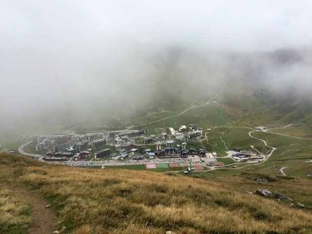
(2) Crossing the Col du Palet, one steps from the sublime to the absurd. Below the pass, the ski industry reigns: Ski lifts lace the bare slopes of the mountain. And then, after walking down the slopes for about 30 minutes, the ski resorts ("stations") Tignes and Val Claret appear in the valley below – all variations upon a single theme: tower blocks with little balconies for each apartment. This is the style of the modern French station de ski, and it's not a pretty sight.
We paused for lunch at a picnic table above Val Claret. The trail forks here: The GR5 descends to Tignes and then follows a valley around the Vanoise massif to Modane. A variant, the GR55, crosses the Vanoise mountains without descending to the lower valleys. As in 1989 (GR5) and in 2002 (when we hiked a Tour de la Vanoise), we opted for the mountain route, the GR55.
(3) Once out of Val Claret, our trail climbed steadily through stark, rocky terrain to the Col de la Leisse (2758 m.), one of the highest passes on our trail. We re-entered the Parc National de la Vanoise. After the pass, we descended to the Refuge de la Leisse (2487 m.). In the wild terrain of the Vallée de la Leisse, the infrastructure of the ski industry was mostly forgotten.
* * *
Hiking from the Refuge d'Entre le Lac to the Col du Palet:

Lac de la Plagne:


The Refuge du Palet, where we paused for coffee:

Yesterday's rain fell as snow at this altitude, and traces of the snow remained this morning.

Crossing the Col du Palet, we entered the Tignes ski area.


Oddly, there is better trail maintenance on the Tignes side of the pass than on the Park side, as evidenced by the many water breaks that we encountered on the trail, such as this one:

This was not the best view we've had for a picnic lunch, but we had a table and the rain had stopped.

Our trail, the GR55, climbs up the valley behind Val Claret.

The tricouleur blaze marks the boundary of the Park.

Approaching the Col de la Leisse:


Descent from the Col de la Leisse:


This is the Plan des Nettes, formerly the artificial lake created by an experimental dam constructed in 1953. The dam was dismantled in 2012, and the Plan des Nettes dried up.

The Refuge de la Leisse:

Nice variant! I was wondering how you were going to avoid Tignes and Val d'Isere. Only thing missing, you'll have to go to Bonneval-sur-Arc, if you haven't been, at the bottom of the Col d'Iseran. Definitely worth the detour.
ReplyDeleteMarie
Happy Birthday Carroll. And again a beautiful etappe. Greating from the low lands.
ReplyDelete